In the MODELLING menu it is possible to handle input data and to create the 3D model.
After uploading the topography, it is possible to do a check on the points of the surface by clicking on “Check topography”, with this option the topographic surface, if necessary, will be corrected in order to optimize the 3D model.
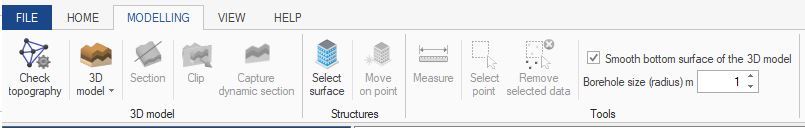
The “3D model” button shows a menu through which it is possible to choose the type of modelling to use, that is geometric type of modelling, possible in the case of regularity in layers present in the surveys, or a manual type of modelling, in which the manual connection between the layers of the different surveys is requested.
Once you created the model, clicking on “Section”, it is possible to track down the lines along which we will be creating the sections of the model.
Another way to carry out the sectioning is by clicking on ”Clip”, which will generate a plan through which it will be possible to see the inside of the model, after finding the spot in which we want to carry out the sectioning, it will be possible to click on “Capture floor section”.
Through “Import structure” it is possible to import DWG or DXF files of a 3D structure to place in the inside of the model.
Through “Move to point” you can move the imported structure, positioning it in a specific spot of the model.
In the tools section, it is possible to measure the distance between two points clicking on “Measure”, or selectioning and removing points from the topographic structure clicking on “Select points” and consequently on “Remove selected”.
By checking the “Uniform surface inferior of the 3D model” box, when the model is created, a horrizontal surface even as the lowest point on the 3D model will be created as inferior surface of the model, by building the model without checking the box, the inferior surface will have a trend defined by the presence of the other surveys and by the topography.
Through the “Survey size” command it is possible to size the survey according to your needs, in relation to the model.
IMPORT STRUCTURE

© GeoStru