BASIN'S MORPHOMETRICAL PROPRIETIES
For the correct construction of flow model and its kinematism the form and structure (morphology) of the basin must be defined. Beyond its outline, information must be available on its: linear properties (reach length, dendritic ramififications etc.); areal properties that describe the areas of affluence to the main reach; and elevation properties that define the inclination of the basin. Among these are determinant the height of the basin (average, least ond greatest) the drop and the inclination.
Tracing outline of the watershed, can be achieved merely numerically. However given the availability of a map or aerial/satellite image in digital form, the watershed boundaries can be traced by copying the image on the work sheet and clicking points along the image optionally adding elevations as you proceed. Elevation of peak height, any saddles and trogh that coincides with the closure or outlet of the basin.
Watershed outline, is entered anticlockwise from outlet back to outlet. Thereafter the main reach is traced and thereafter tributary reaches.
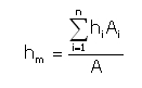
Average basin height is determined by subdividing the basin area A in sub areas Ai that are delimited by two adjacent level curves of which the average height (hi) is assigned. The average height of the basin is calculated as the average heights hi wighed by the extent of the partial areas Ai:
The average height Hm, unlike the average altitude hm that is relative to sea level, is relative to the closure (outlet) elevation and is defined by:
Hm = hm - hmin
Where hmin is the closure (outlet) elevation.
The Hypsographical curve construction allows to acquire information on the area distribution of different altitude slices. This is obtained through the definition of the medium height ordinate hi [m. above sea level).] and in abscissa the area Ai [Km²] above the height hi.
So, to the maximum quota corresponds a null surface and to the minimum quota the complete basin area. The area subtended by the Hypsographic curve represents the basin volume and the ratio between this and basin's surface gives the medium altitude hm.