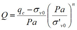
The method of Robertson e Wride uses the soil behavior type index Ic that is calculated using the following formula:
![]()
![]()
where:
qc measured point resistance
Pa reference stress (1 atmosphere) in same measurement units as σ'v0.
fs sleeve friction
n exponent depending on the soil type
Initially is assumed n = 1, as for a clayey ground and is proceed to the calculation of Ic with the formula above.
If IC > 2.6 the soil is probably clayey type and the analysis stops. The soil is not considered at risk of liquefaction.
If IC ≤ 2.6, means that the hypothesis assumed is incorrect, the soil has a granular nature, Q will be recalculated using the above relationship and using as an exponent n = 0.5.
If still IC ≤ 2.6, means that the hypothesis is correct and the soil is probably not plastic and granular.
If instead IC > 2.6, means that the hypothesis is wrong again and the soil is probably muddy. Q must be recalculated again putting n = 0.75.
Having calculated Ic, we proceed with the correction of the cone resistance qc using the following expression:
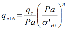
Where the stress exponent n is the same used in the computation of Ic.
The correction to the cone resistance due to the content of fine material is determined by:
![]()
![]()
The liquefaction resistance for a magnitude equal to 7,5 (CRR7,5) is calculated as:
•if (qc1N)cs < 50:
![]()
•if 50 ≤ (qc1N)cs < 160:
![]()
CSR is calculated using the formula mentioned in the Introduction chapter of this Guide, for different magnitude must be inserted the corrective factor MSF (Magnitude Scaling Factor) as recommended by NCEER (see Table 1 - Seed Idriss method).
To determine the values of the reduction factor rd are used the formulas recommended by an expert group of NCEER (National Center for Earthquake Engineering Research):
if z < 9,15 m:
![]()
if 9,15 ≤ z < 23 m:
![]()
where z is the depth in meters.
© Geostru