This window enables the properties of terrain layers and a display texture to be specified or displayed for amendment. The window consists of two panes. The major one is a table of layer properties one row to each layer. The other is a rotating list of bitmaps to represent different soil types grouped by major type (cohesive, cohesionless, rocks and others). Instead of entering each layer data, previously defined layer descriptions may be recalled from the database. The table contains the following columns:
Nr.
Order number of the layer
N.B.: Layer data should be entered from the upper layer and progressively downwards.
DB
Drop down list containing the terrain types currently present on the database (Manufacturer supplied and user added). Clicking on one fills the row. The data thus entered may be altered individually if opportune.
Layer thickness
Layer thickness in meters.
Gk
Unit weight of the layer.
Gk saturated
Saturated unit weight of the layer.
For analysis performed in terms of total stresses in the absence of ground water must be entered the saturated unit weight.
|
Fik
Characteristic parameter of the angle of shearing resistance, in degrees. Where the GWT is present, insert the effective parameter for analysis in drained conditions or zero for undrained condition.
Cohesion (ck)
Terrain cohesion. Where the GWT is present, insert the effective parameter for drained condition the total parameter for undrained condition.
Undrained cohesion (cuk)
Insert the total parameter of the terrain cohesion for analysis in undrainded conditions.
Modulus of Elasticity
Elasticity or Young's modulus for the terrain. The parameter is required for Schmertmann computation of settlements. If this is not specified, settlements are calculated with the oedometric method (requires entry of oedometric modulus value). If both modules are specified then settlement is calculated by the oedometric method.
Oedometric Modulus
Deformation modulus obtained though the oedometric tests (conditions of inhibited lateral expansion). This parameter is required to evaluate the settlement by the oedometric method. If Young's modulus is assigned by the user instead of the oedometric modulus, the settlements are calculated by the method of Schmertmann.
Additional data
In order to calculate the oedometric settlements, consolidation settlements or post-seismic settlements additional data needs to be entered by activating the "Additional data" window as shown in the image below:
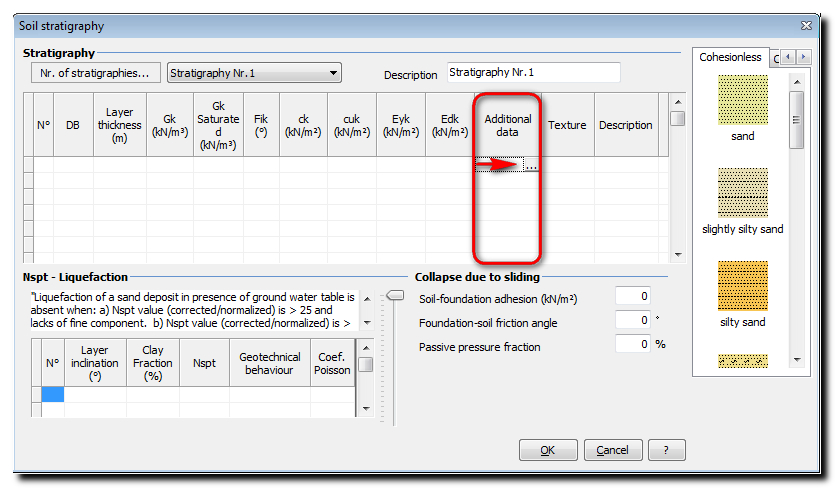
A subsidiary dialog window opens "Additional data for settlement computation" for the specification of the parameters needed for the computation of oedometric settlements and post-seismic settlements.
In the calculation of oedometric settlements, the user can choose to take into account the viscous effects or not from the drop down form: "Oedometric modulus" or "Parameters RR, CR".
In the first case it is necessary to define, for each layer, the oedometric modulus (Ed) and the coefficients Cs and Cv, where:
•Cs (secondary compression index), parameter derived from the branch of a secondary compression of an oedometer test. Its value is necessary for the evaluation of secondary failure of a viscous nature.
•Cv (primary vertical consolidation index), required for the computation of settlement over time with Terzaghi’s mono dimensional method.
•
In the second case must be entered the RR and CR parameters (recompression and compression ratio) and have entered in the "Soil stratigraphy" window the value of the oedometric modulus of the layer. The settlement will be calculated without taking into account the secondary effects.
For the software to calculate the post-seismic settlements, for each layer, the user must declare a set of parameters as is highlighted in the images below:
|
|
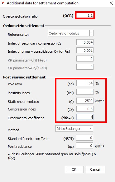
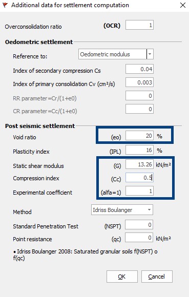
Parameters necessary for the computation of post-seismic settlements, in red for cohesive soils and in blue for granular soils
Texture
Selects texture/color to be associated with current layer. Click the mouse to open a color palette from which the color to be applied can be chosen. Note that if the row was filled from the database, the color will probably already be assigned, but it can be altered in the same way. If otherwise it is desired to assign a texture, select a relevant one from the list in the right side pane and drag it to this column.
Description
In this cell the user can type a text for the description of the corresponding lithology.
If in "General data" was chosen "Rock" for "Soil type", in the table of the stratigraphy will be required, for each layer, the parameter RQD (Rock Quality Designation). Assign a value between 0 and 1.
|
In the presence of soils consisting of loose sands in presence of water table, even if they contain a fine silt-clay fraction, it should be verified the susceptibility to liquefaction using one of the methods generally adopted by the geotechnical engineering.
Clay Fraction %
Nspt Average number of blows in the layer obtained from a SPT soil test, can be dynamically assigned by going on the layer and moving the graduated cursor with the mouse.
Geotechnical behaviour Indicate whether the layer is cohesive or cohesionless.
|
Layer inclination
Indicate the inclination of the layer.
Poisson's ratio
Poisson's ratio value for the layer. This parameter is required for computation of increments of tension below the foundation according to Westergaard.
![]() Sliding verification - Collapse due to sliding
Sliding verification - Collapse due to sliding
In accordance with the design criteria for ultimate limit state, the stability must be verified for collapse due to sliding besides the verification for general failure. In case of collapse due to sliding the resistance is calculated as the sum of a component due to adhesion and a component due to foundation-soil friction, the lateral resistance resulting from passive soil thrust can be brought into account according to a percentage indicated by the user.
Soil foundation adhesion Enter the value of the adhesion in the indicated unit measure.
Soil foundation friction Enter the value of the shearing resistance angle in degrees at the base of the footing.
Passive thrust ratio Indicate the percentage of passive thrust to consider in the verification for collapse due to sliding.
|
© GeoStru