Different soil layers can be defined in the stratigraphy window:
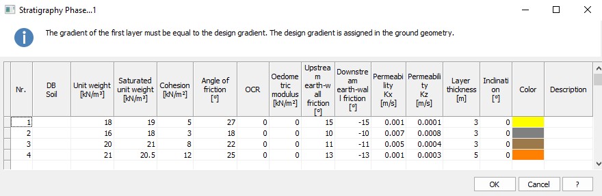
For each layer, the following data must be defined:
•Nr: Identifies the layer by an ascending numeric index from surface in depth.
•DB Soil: Allows setting initial characteristics derivable from a soils database provided with the software. The database can be modified by altering existing characteristics or deleting/adding soil types (in the installation folder, search for Soils/Soils_EN.csv).
•Unit weight: Expressed in kN/m3 (order of magnitude = 17/20 kN/m3), it represents the natural weight of the soil.
•Saturated unit weight: Expressed in kN/m3 (order of magnitude = 18/21 kN/m3), it represents the saturated weight of soil - to be entered in the presence of groundwater. In the presence of groundwater, for the analysis in drained conditions, the software estimates the effective pressures starting from the effective unit weight.
•Cohesion: Expressed in kN/m2 (order of magnitude 1/5 kN/m2).
•Angle of friction: Expressed in degrees (order of magnitude = 22/30°).
•Over-Consolidation Ratio (OCR): Depends on the tensional history of the site under examination (order of magnitude = 1/2)
•Oedometric modulus: Is the normal modulus of elasticity estimated in oedometric conditions, expressed in kN/m2 (Order of magnitude = 10000 kN/m2).
•Upstream earth-wall friction: Expressed in degrees (order of magnitude = 10/12°). Usually the regulations impose values no higher than 2/3 of the angle of internal friction of the ground.
•Downstream earth-wall friction: Expressed in degrees (order of magnitude = 10/12°). Usually the regulations impose values no higher than 2/3 of the angle of internal friction of the ground.
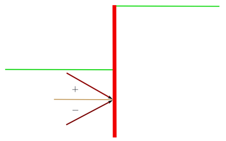
Direction of the passive thrust
The soil-downstream wall friction angle must be less than j/2. Otherwise it is necessary to consider the non-coplanarity of the sliding surfaces.
•Permeability Kx: Expressed in m / s (parameter necessary to plot the flow grid)
•Permeability Kz: Expressed in m / s (parameter necessary to plot the flow grid)
•Layer thickness: Estimated starting from the lowest point of the layer previous to the one to be defined; it is expressed in m.
•Inclination: Expressed in degrees.
•Color: Identifies the layer inside the drawing area.
•Description: Name associated by the user to the inserted layer.
Some clarifications must be made as regards the definition of the layer thickness and inclination.
Layer thickness: The thickness of the layer is measured along the vertical passing through the origin of the fixed reference system (which, bear in mind, coincides with the head of the bulkhead). For more clearness, please refer to the following figure:
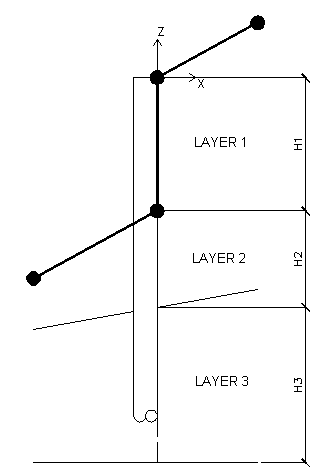
Layer inclination: The inclination of the layer is the angle of rotation relevant to the bottom of the layer taken into consideration. The rotation of the layer is defined with regard to the pole obtained through the intersection between the vertical line passing through the origin and the horizontal line which identifies the lower part of the layer to be defined.
© GeoStru