The stilling basin is a work complementary to the weir and is used to dissipate a part of the energy of the stream. A stilling basin is made up of the following elements:
A basin coating
An auxiliary dam
In the framework considered by the GDW programme, we can distinguish four types of basins:
Basin not coated with auxiliary dam
In this case, the formation of the basin is due to the laying of an auxiliary dam downstream the weir. In this case, the basin is not coated (see the figure below):
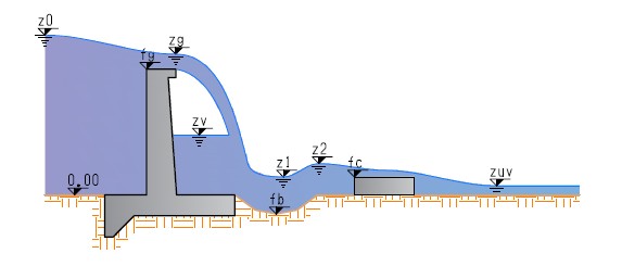
Basin not coated with auxiliary dam
It should be noticed that in this case the phenomenon of erosion is lessened, though not completely removed.
Embankment basin, coated with auxiliary dam
In this case, besides the laying of an auxiliary dam there is also a coating extending on the space included between the auxiliary dam and the downstream foot of the weir foundation (see following figure):
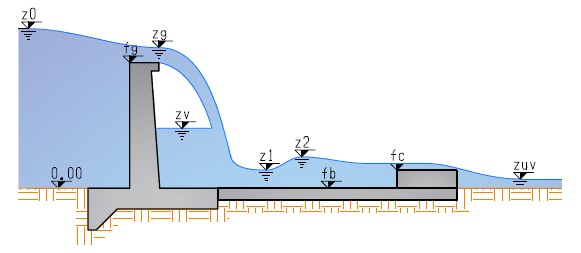
Embankment basin coated with auxiliary dam
In this case, the phenomenon of erosion is completely removed, since the coating material of the basin is extremely erosion-resistant.
Depression basin, coated with auxiliary dam
In this case, unlike for the embankment basin, the level of the basin surface is lower than the reference soil level, and the bottom level of the notch n the auxiliary dam coincides with the reference soil level (see following figure):
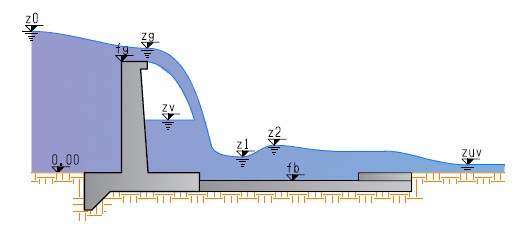
Depression basin coated with auxiliary dam
Absence of Basin and auxiliary dam
This is the most unfavourable case in terms of erosion. In fact, not only the bottom has scant capabilities of resistance to the phenomenon of erosion downstream the weir, but there is no stilling device. In this case, the main excavation depths shall be checked:
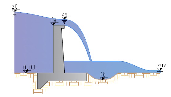
Absence of basin and auxiliary dam
As regards the input to be entered by the user, please refer to the following figure:
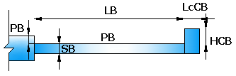
Geometrical data of the stilling basin
Where
LB [m]
Basin length
PB [m]
Basin bottom level with respect to the reference plane represented by the soil.
SB [m]
Basin thickness
HCB [m]
Height of the auxiliary dam measured from the reference plane represented by the soil.
LcCB [m]
Crowning width of the auxiliary dam.
© GeoStru